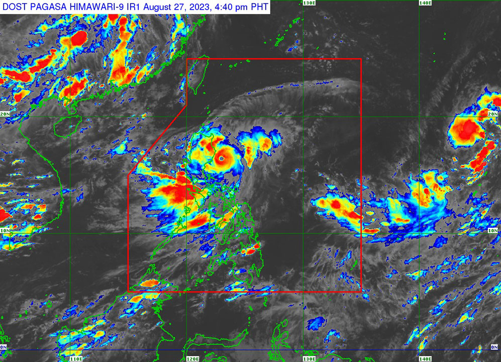
Goring intensifies into super typhoon; storm signals raised over Luzon areas

TROPICAL CYCLONE Goring (international name: Saola) on Sunday intensified into a super typhoon, prompting the state weather bureau to raise storm signals over parts of the main Philippine island of Luzon.
In a 2 p.m. bulletin, the Philippine Atmospheric, Geophysical and Astronomical Services Administration (PAGASA) said Goring was seen 90 kilometers east-northeast of Casiguran, Aurora province.
It was moving southward with maximum sustained winds of 185 kilometers per hour (kph)and gusts of up to 230 kph.
PAGASA hoisted tropical cyclone wind signals over various parts of Luzon due to typhoon-level winds.
Signal No. 3 was raised over the eastern portions of Isabela, specifically Divilacan, Palanan, Dinapigue, Ilagan City and San Mariano.
“Moderate to significant impacts from storm-force winds are possible within any of the areas where Wind Signal No.3 is hoisted,” it said.
Signal No. 2 was raised over the easter portion of mainland Cagayan, the northern and central parts of Isabela, the extreme northern portion of Aurora and the eastern portion of Quirino province.
Batanes, the rest of Cagayan including Babuyan Islands, the rest of Aurora, the rest of Quirino, the rest of Isabela, Apayao, Nueva Vizcaya, Ifugao, Mountain Province, Kalinga, Abra, the eastern portion of Ilocos Norte, Polillo Islands, the eastern part of Benguet, the eastern portion of Nueva Ecija and Calaguas Islands were all under Signal No. 1.
The Philippines lies along the typhoon belt in the Pacific and experiences about 20 storms each year. It also lies in the so-called Pacific Ring of Fire, a belt of volcanoes around the Pacific Ocean where most of the world’s earthquakes strike.
The country constantly experiences unavoidable losses and damage equivalent to 0.5% of its annual economic output mainly due to an increasingly unpredictable climate, according to the Finance department.
PAGASA said the southwest monsoon, which was enhanced by Goring, would bring occasional or monsoon rains over the western portions of central Luzon, southern Luzon and the Visayas in the next three days.
It added that a gale warning was in effect for the northern and eastern coastal areas of Luzon.
“Disruption in civilian maritime activities is expected over these areas due to hazardous sea conditions,” the agency said.
The super typhoon will move in a lopping motion and by Aug. 28, the storm will turn northeastward and northward before shifting northwestward on Tuesday.
“Goring is forecast to remain at super typhoon category until it makes landfall over southern Taiwan,” the weather bureau said.
“It is likely that Goring will emerge over the Taiwan Strait and exit the Philippine area of responsibility on Friday as a severe tropical storm or a typhoon in its lowest limit,” it added.
Meanwhile, about 1,473 people from 448 families fled their homes and took refuge on safer grounds in Cagayan province, the Provincial Disaster Risk Reduction and Management Council said.
At least 388 people from 141 families were brought to evacuation centers while the rest took refuge in their relatives’ homes.
Some road systems in the province were impassable due to floods after two days of nonstop rains. Abariongan Ruar-Abariongan Uneg road, Tammuco-Balagan-Abaruangan Ruar road and Tamban Bridge in Sto. Niño town were closed.
PAGASA said the forecast rainfall would be generally higher in elevated or mountainous areas. Under these conditions, flooding and rain-induced landslides are possible especially in areas that are highly susceptible to these hazards.
“The public and disaster risk reduction and management offices concerned are advised to take all necessary measures to protect life and property,” it said. “Persons living in areas identified to be highly or very highly susceptible to these hazards are advised to follow evacuation and other instructions from local officials.” — Adrian H. Halili and Artemio A. Dumlao


